Classical, Islamic, and Asian Technology
Western European countries such as Portugal, Spain, and England were developing their naval technology. They were aware of traditions of sailing that went back to the classical Greeks, such as using the stars to navigate. They combined this knowledge with new ideas developed by Islamic and Asian sailors and scholars, which they learned about because of the cross- cultural interactions resulting from trade networks. Al-Andalus, in what is now Spain, was a place where Islamic ideas diffused into Europe.
The leading European figure in this development was Portuguese ruler Prince Henry the Navigator. While he never sailed far enough out to sea to lose sight of land, he strongly supported exploration. He financed expeditions along Africa’s Atlantic Coast and around the Cape of Good Hope. With his backing, Portugal explored African coastal communities and kingdoms before other European powers.
Advances in Ideas As scholars gathered knowledge, they improved the safety of sailing on the ocean. For example, Newton’s discovery of gravitation increased knowledge of the tides. As a result, sailors could reliably predict when the depth of water near a shore would be decreasing, thereby exposing dangerous rocks. As people kept increasingly accurate records on the direction and intensity of winds, sailors could sail with greater confidence.
Improvements in cartography also improved navigation. An astronomical chart is any map of the stars and galaxies. Mariners relied on these maps to guide ships’ direction, especially before the introduction of the compass, using the skies to help them determine their location. Ancient astronomers in Babylonia and Mesopotamia had created star charts as early as the 2nd millennium B.C.E. Charts by Chinese astronomers date back to the 5th century B.C.E. Charts were also used widely by classical Greek astronomers. Using telescopes to help create astronomical charts began in 1609, and the practice was widely used to map the stars by the end of the 17th century. Astronomers typically divided the charts into grids to help locate specific constellations and astronomical objects.
Advances in Equipment Several developments in the equipment used on ships made sailing safer and faster than ever. Ships moved adroitly, aided by a new type of rudder, another idea imported from China. The astrolabe, improved by Muslim navigators in the 12th century, allowed sailors to determine how far north or south they were from the equator.
The compass is the primary direction-finding device used in navigation. It works either with magnets or a gyroscope, which is a wheel or disk mounted to spin rapidly around an axis in various directions. Other compasses determine the location of the sun or a specific star. The magnetic compass, originally invented in China, allowed sailors to steer a ship in the right direction. It is the oldest and most familiar. It was discovered by mariners in both China and Europe in the 12th century. This type of compass works as Earth itself acts as an enormous bar magnet. Earth’s magnetic field is almost parallel to the north- south axis of the globe, which means that freely moving magnets, such as those in a compass, take on the same orientation.
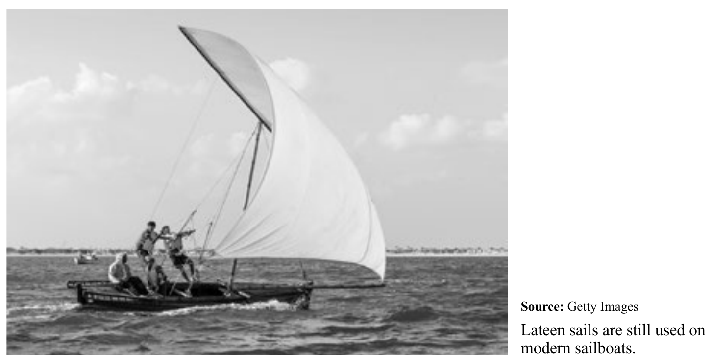
The lateen sail, or a ship sail in the shape of a triangle, was a pivotal piece of technology. Used by Arab sailors and in the Indian Ocean, it significantly affected medieval navigation and trade. The ancient square sails that preceded the lateen allowed sailing only in a single direction and had to be used with the wind. The lateen, however, could catch the wind on either side of the ship, allowing it to travel in different directions. When used with the square sail, the lateen allowed sailors to travel successfully into large bodies of water, including oceans, for the first time, thus expanding trade routes.
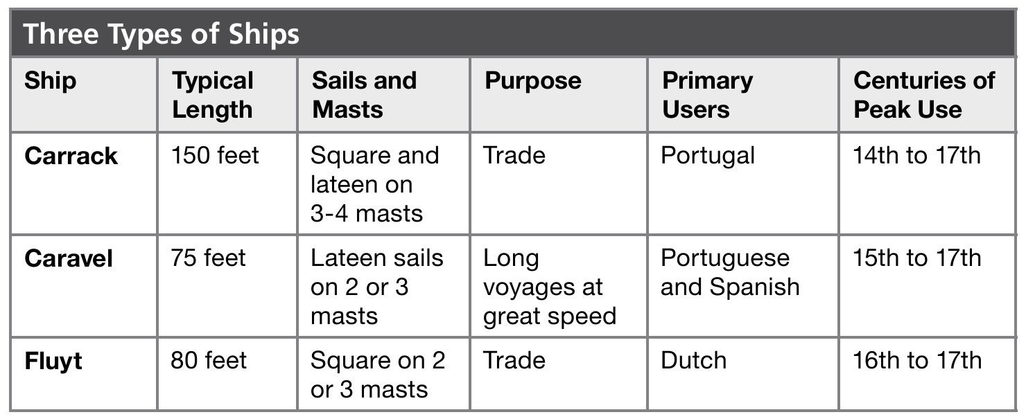
New types of ships also improved trade. By adjusting the ratio of length to width of a ship, adding or reducing the number of masts, and using different types of sails, builders could adapt ships to improve their efficiency. (Connect: Compare the technological advances of the Mongols and Chinese of the 12th and 13th centuries with those in the chart below. See Topic 2.1.)
Long-Term Results The long-term result of combining navigational techniques invented in Europe with those from other areas of the world was a rapid expansion of exploration and global trade. About the only part of the Afro- Eurasia world not affected by the rapid increase in global trade was Polynesia, since it was far removed from trading routes.
The introduction of gunpowder, another Chinese invention, aided Europeans in their conquests abroad. Soon enough, however, sea pirates also used the new technology, particularly the Dutch pirates known as Sea Beggars.
In North Africa and in the trading cities along Africa’s east coast, Islam spread rapidly as a result of the growth of the Abbasid Empire, centered in Baghdad, and the activities of Muslim merchants. Interactions among various cultures inside and outside of Africa brought extensive trade and new technology to the continent.
Navigational techniques continued to spread throughout the 17th century. Russia’s Tsar Peter the Great visited Western Europe in 1697 to observe military and naval technology. His interest in European technology led him to hire technicians from Germany and elsewhere to help build Russia’s military and naval power.
KEY TERMS BY THEME
ECONOMICS: Europe
TECHNOLOGY: Navigation
GOVERNMENT: Europe primogeniture laws
cartography
maritime empires Omani-European rivalry
astronomical chart